
![8200SG-Studio-480x32001[1]](https://enermak.com/wp-content/uploads/2023/12/8200SG-Studio-480x32020011-1.jpg "8200SG-Studio-480x32001[1]")
![8200SG-Studio-480x32001[1]](https://enermak.com/wp-content/uploads/2023/12/8200SG-Studio-480x32020011-1-187x187.jpg)
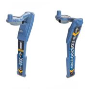
RD8200SG
Android™ ve iOS® işletim sistemlerinde kullanılabilen RD8200SG – Survey Grade ile gömülü altyapı hatlarını tek bir işlemde bulun ve haritalandırın. RD8200SG, kullanıcıların gömülü altyapı hatlarını hassas bir şekilde haritalandırmasını sağlayan en gelişmiş, birleşik haritalama ve altyapı şebeke bulma çözümüdür.
- Estimated Delivery: 4-6 hafta
- Pickup from warehouse: Fast delivery
Radiodetection RD8200SG: Yer Tespiti ve Hassas Haritalama Bir Arada
RD8200SG (Survey Grade), yeraltı kamu hizmetlerini (kablo ve boru) tespit ederken aynı zamanda santimetre hassasiyetinde haritalama yapmanıza olanak tanıyan devrim niteliğinde bir lokatördür. Artık yer tespiti ve haritalama için iki ayrı ekipman taşımanıza gerek yok; RD8200SG ile “Yolunuzu Siz Çizin” (Map It Your Way).
Öne Çıkan Ana Özellikler:
| Hassas GNSS | Entegre anteni sayesinde ek bir GNSS alıcısı gerektirmeden yüksek doğruluk sağlar. |
| Eğilme Gerektirmez | Cihazı geriye doğru eğmeye gerek kalmadan, anten ve yer arasındaki mesafeyi otomatik olarak hesaplar. |
| Mobil Entegrasyon | Android ve iOS cihazlarla uyumludur; verileri anında buluta veya mobil uygulamaya aktarır. |
| Dayanıklı Tasarım | Yağmur, toz ve aşırı sıcaklık gibi zorlu saha koşulları için Birleşik Krallık’ta tasarlanıp üretilmiştir. |
Neden RD8200SG Tercih Edilmeli?
- Verimlilik: Tespit ve haritalama işlemlerini eş zamanlı yürüterek zaman kazandırır.
- Kolay Kullanım: Operatörler için minimum eğitim gerektirir; tek tuşla veri kaydı yapar.
- Esneklik: Kendi düzeltme servisi sağlayıcınızı (RTK) seçebilir ve endüstri standardı dosya formatlarında çıktı alabilirsiniz.
- Hassasiyet: Hem yer tespitinde hem de koordinatlamada en yüksek doğruluk payını sunar.
Kullanım Alanları:
- İnşaat ve Altyapı Çalışmaları
- Su ve Kanalizasyon İdareleri
- Enerji ve Petrol & Gaz Hatları
- Telekomünikasyon Şebekeleri
- Belediyeler ve Şehir Planlama
Not: Ürün paket içeriği ve opsiyonel yazılım özellikleri için lütfen satış ekibimizle iletişime geçin.